|
Location and History of Marion
Island
The following bits were obtained from the SANAP website, where other
interesting facts about Marion Island can be found.

A view of Prince Edward Island (neighbour of Marion Island), as seen from the
SA Agulhas.
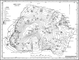
Location
Marion
Island, the larger of the Prince Edward Islands group, is situated at
46°54' South and 37°5' East in the Southern Indian Ocean. The island is
situated in the 'roaring forties' and lies approximately 1770 km south
east of Port Elizabeth, South Africa. The French Crozet Island Group lies
some 950 km to the east. Marion Island is about 290 km 2 in
area with 72 km of mostly cliff-face coastline.
Geology
Marion
Island represents one of the peaks of a coalescing shield volcano. The
island has been dated between 0.5 to 1 millions years. This is very young
if compared with the rest of the world as well as other volcanic islands
in the region. The highest peak on the island is about1300 m above sea
level. If taken from the ocean floor the volcano is about 5000 m high.
Until 1980 it was thought that all volcanic activity has stopped and the
volcano was classified as extinct. In 1980 though, there was an eruption
on the island (at Kaalkoppie) and because of
this it is now classified as an active volcano. Two main types of lava
are found on the island, namely Grey lava and Black lava. Grey basalt
lava is the older of the two types (270 000 – 48 000 years). It is
found in the form of high lying ridges, which have been given a smoothed
appearance by thousands of years of glacial activity. This also means
that the biggest part of the island was covered in ice sheets at some
stage in the past. Examples of these high lying areas of Grey lava are Stony
Ridge and Skua Ridge. Black basalt lava is a
more recent addition (15 000 – 21 years) of lava to the island and
has a rough black appearance. It has an uneven and rough appearance
because it has never been subjected to glacial activity. The topography of
the island is dominated by Black lava flows. There are
conical red and black scoria cones scattered all over the island. This is
evidence of explosive eruptions from which many of the large lava flows
arose. Only one glacier remains on the island. It is found at about 1000m
above sea level and is called The Ice Plateau. This plateau is shrinking
all the time and is now much smaller than 30 years ago. The coastline
consists mostly of rugged cliffs with sheer rock faces. There are few
beaches, of which only two can be classified as sandy. The rest of the
beaches are pebble or boulder beaches.
Discovery and annexation
Marion
Island was first discovered in 1663 by the Dutch ship Maerseveen.
The discovery was accidental and no landing was made on the island. More
than one hundred years later, in 1772, it was seen again by Frenchman
Marion du Fresne, who
was looking for Antarctica when he came across the island group. Thinking
it was part of Antarctica, he spent 5 days trying to make a landing
before he discovered it was only two small islands. They left and never
returned. After four more years, Captain Cook also saw the islands, but
could not make a landing because of bad weather. The first recorded
landing on the island was in 1803 by a group of sealers, but they did
find signs of earlier occupation. In late 1947 and early 1948 South
Africa took possession of both Marion and Prince Edward islands. Under
the command of Lieutenant-Commander John Fairburn the two islands were
annexed and the South African flag raised. The
first expedition to the island was a meteorological team, led by Allen B.
Crawford. Meteorologists have occupied the island ever since, joined in
later years by scientists conducting research on the environment and
ecology. One of the first documented records of biological observations
on Marion Island were those made by Richard Harris,who observed and collected seabirds during a
British sealing expeditionin 1830. There are
two major chapters in the history of Marion Island - sealing activities
and the introduction and subsequent eradication of cats. Both had major
impacts on the current state of the island and its wildlife.
Sealing
During the
19th century elephant seal oil was the primary natural resource collected
on the island. This was done by boiling the seal blubber in large trypots either on the beach or on board the ships.
Harvesting of fur seal and penguin skins for gloves also occurred on the
island. Some remnants of these days still scatter the beaches. Remains of
huts can still be seen but most sites are protected and the artefacts stay undisturbed in their wet, cold graves.
The earliest documented evidence of sealing relates to the landing of a
gang of sealers from the Catharine, Henry Fanning as captain, in December
1803 or January 1804. At that time the Islands were an important
rendezvous for sealers. Sealers of different nationalities including
American, French and British exploited the Islands. The second half of
the 19th century saw a rise in the number of Norwegian sealers as well as
sealers based in Cape Town. The first Cape Town based sea elephant oil
industry on the Prince Edward Islands was established in 1833.
Large-scale sealing occurred until November 1930 when seal numbers had
dropped too low to be commercially exploitable. The ship SS Kildalkey made the final sealing expedition to the
Island and took about 1 450 seals on this last trip. Today sealers still
roam the Island, not carrying clubs and guns but tagging equipment and
scales. Harvesting of seals has been replaced by research of these
wonderful creatures.
The Cat Eradication Program
Five
domestic cats, including a castrated, orange striped male tabby and a
black and white female together with three kittens were introduced during
1949 on Marion Island. These felines were brought to the island to help
eradicate a mouse problem in the base. As cats do they soon multiplied
and the first feral cat was seen in 1951. By 1975 the population had
increased to more than 2 000 cats feeding on thousands of burrowing
petrels, a much easier prey than the mice they were supposed to hunt. In
1975 alone the cats ate just under half a million birds and species such
as the Common Diving Petrel, the Soft Plumage
Petrel andthe Grey Petrel became extinct on
Marion IsIand. With other remaining bird
species also at risk it was decided to initiate the Marion Island Cat
Eradication Program. In 1977 the entire cat population was estimated
around 3 405 individuals. A few animals were infected with the highly
specific disease feline panleucopenia. By 1982
there were an estimated 615 cats remaining. During the spring of 1986 a
secondary control measure in the form of nocturnal hunting was initiated
on full scale. For three summers, eight two-man teams using
battery-operated spotlights and 12-boreshotguns killed approximately 803
cats in total. The progressive decrease in hunting success and the
sighting rate of cats suggested that hunting alone was no longer
sufficient in reducing the numbers. Traps were usedand
between 1989 and 1991 the remaining cats were removed. During the
12-monthperiod post April 1991, only eight cats were trapped and three
trapping teams recorded no sightings. It is now believed that complete
eradication of feral cats on Marion Island has been achieved after 19
years.
Shipwrecks
The best
known shipwreck around the Prince Edward Islands is the Solglimt at Ships Cove.
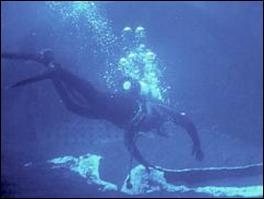
The image is of the sealing vessel which ran aground in 1908 at Ships
Cove. The survivors constructed a small village against the cliff,
housing 70 men. The wreckage lies in +/- 8 meters of water. Most of the
wreck is covered by the sandy bottom with only four visible structures
remaining underwater. The largest section resembles that of the
boiler/engine room, from where the displayed artifacts in the bar of
Marion Base were salvaged.
|