The IGS Station and its Role in Land Delivery in Zambia
L. Combrinck1 and
P. Nsombo2
1. HartRAO Space Geodesy Programme, P. O. Box 443, Krugersdorp 1740, South Africa,
e-mail: ludwig@hartrao.ac.za
2. Department of Surveying, School of Engineering,
University of Zambia. P. O. Box 32379
Lusaka, Zambia. E-mail: pnsombo@eng.unza.zm
Abstract
The Zambian geodetic network suffers from serious
inconsistencies emanating from lack of a homogenous network. The Zambian
geodetic network has only been partially adjusted. Thus work based on the
control points is equally unsound as errors arising from the control network
(primary to quaternary) propagate into the smaller networks used for
topographic, engineering, and cadastral surveys.
The need to re-observe the geodetic network cannot be
over emphasized. Thus in collaboration with The Royal Institute of Technology
(KTH), in Sweden, two GPS campaigns were carried out: one in 1999 and the other
in 2000. Further work was done, one around Lusaka and the other in Eastern
Zambia in 2001 and 2002 respectively.
The above work, however, still suffers from
reliability as the GPS solutions were obtained from a single point solution
(SPS). No one point is well known in terms of WGS 84 coordinates (ITRF
coordinates?). In order to address this problem, an International GPS Service
(IGS) GPS station was installed under the support of the Space Geodesy
Programme of the Hartebeesthoek Radio Astronomy Observatory (HartRAO), in South Africa and in collaboration with
the Zambia Survey Department (ZSD) and the Department of Surveying, University
of Zambia (UNZA).
This paper discusses the role of the IGS station viz a
viz surveying and land delivery. With this precisely known station, a
re-computation of the already observed
networks is now meaningful.
1.0 Introduction
The Zambian
geodetic network suffers from serious inconsistencies emanating from lack of a
homogenous network. The Zambian geodetic network has only been partially
adjusted. Thus work based on the control points is equally unsound as errors
arising from the control network (primary to quaternary) propagate into the
smaller networks used for topographic, engineering, and cadastral surveys.
The need to
re-observe the geodetic network cannot be over emphasized. Thus in
collaboration with The Royal Institute of Technology (KTH), in Sweden, two GPS
campaigns were carried out: one in 1999 and the other in 2000. Further work was
done, one around Lusaka and the other in Eastern Zambia in 2001 and 2002
respectively.
The above work,
however, still suffers from reliability as the GPS solutions were obtained from
a single point solution (SPS). No one point is well known in terms of WGS 84
coordinates. In order to address this problem, an International GPS Service
(IGS) GPS station was installed under the support of the Space Geodesy
Programme of the Hartebeesthoek Radio Astronomy Observatory (HartRAO), in South
Africa and in collaboration with the Zambia Survey Department (ZSD) and the
Department of Surveying, University of Zambia (UNZA).
The installation of this IGS station
(ZAMB) now makes it possible to realize reliable coordinate solutions for all
GPS surveys. This in turn will lead to reliable mapping and survey operations
and consequently contribute to a quicker land delivery process.
2.0 Re-observation
of the Zambian primary, secondary and tertiary control stations.
It is well known that many of the existing
national networks in Eastern and Southern Africa are tied to the Arc of the
30th Meridian as is the case of Zambia.
Thus in 1999, and in conjunction with the Zambia Survey Department
(ZSD), and with support and cooperation of the Swedish International
Development Agency (SIDA), and the Royal Institute of Technology, (KTH); a GPS
campaign was carried out to re-survey control stations around the Arc. This GPS
survey comprised ten (10 No.) Zambia Primary (ZP) control points and one (1
No.) Zambia Tertiary (ZT) control point. Initially, over 20 control points were
selected but could not all be observed due to varied problems -mainly being
inaccessibility and limitation in time. The configuration of the net is
illustrated in figure 1 below.
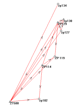
Fig.
1. Part of the GPS control network in Northern and Eastern Zambia
The Equipment used during the campaign were
Leica’s RTK 300 series the static 200 series. A total of six receivers were
used. Centring plates shown in figure 2
were used in the survey (as shown below).
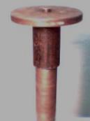
Fig.
2 Centring plate
2.1 Computation of the net
Three stations, ZT500, ZP114 and ZP129 continuously
observed during the campaign. Thus three receivers roved. Observations took six
working days. ZT500 was Computed from HRAO using the Bernese software, while
all the other stations were computed using the SKI software. Baseline distances ranged between 46 – 790km.
Preliminary results show loop misclosures ranging from 0.2 to 1.5ppm.
Transformations to Clarke 1880 using the
Molodensky-Badekas model, were performed in 4 configurations as below:
- All the 11 observed points
- Northern part of the net. 5 common points around reference station
ZP129 (ZP129, ZP121, ZP127, ZP130, and ZP134)
- Middle part of the net. 5 common points around reference station
ZP114 (ZP114, ZP116, ZP118, ZP119 and ZP121)
- Southern part of the net, 7 common points using ZT500, ZP102,
ZP114, ZP116, ZP118, and ZP121.
We present the estimates of the transformation
parameters obtained from the first set, i.e. using all the eleven points. The
geocentric geoidal heights were estimated from Nsombo (1998). The local geoid
is estimated using the abridged Molodesnky formula.
DX = 152.359 ±
0.425 m
DY =
60.814 ± 0.425 m
DZ = 297.384
± 0.425 m
Rx
= -11.915 ± 0.371²
Ry
= 1.424 ± 0.788²
Rz
= 8.451 ± 1.445²
M =
-8.328 ± 1.773 ppm
2.2 RTK
Pilot Project Chilenje South, Lusaka
In collaboration with KTH, a pilot project was
undertaken to demostrate the capabilities of GPS Real Time Survey (Real Time GPS Kinematic mode, or RTK) for
cadastral purposes. This is how a pilot project area was selected in Chilenje
South, Lusaka to test the RTK GPS equipment brought from Sweden. Approximately
a complex of 200 small house plots had to be set out. The results from the tests not only confirmed our expectation but
also proved that with respect of economy and the precision required, the method
is the quickest and more reliable than any other known today. Point position errors was estimated at ![]() @ ±0.029 m , which is within accuracies
that could be achieved by the conventional methods (Sjöberg et. al. 2002).
@ ±0.029 m , which is within accuracies
that could be achieved by the conventional methods (Sjöberg et. al. 2002).
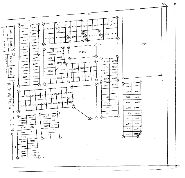
Fig. 3. Pilot
project in Chilenje
2.3 Re-survey of
the Greater Lusaka control network
Between July and September, 2001, the whole control network over Greater Lusaka (encompassing areas beyond the Lusaka District boundary) was re-observed using Leica’s 200 series receivers. Two M.Sc. students who were undertaking minor field studies carried out the work.
Four sub-networks were established, with ZT500, ZS73, ZT28, ZT523, being reference stations. However, ZT500 was chosen to be the base of the networks, due to the, soon to be established, IGS station. The observation time for the references was set to two hours, with 10 second's observation rate, in order to get high accuracy and to be able to resolve the ambiguities. The distance between reference and rover points in the smaller networks were much shorter so the observation time was set to thirty minutes at three seconds observation rate. Every point was planned to be observed in two sessions. The figure 4 below shows the network. Average loop misclosures lie between 1.3 and 2.9ppm.
Transformation parameters for 13 common points yielded the following parameters for the region:
DX = 162.146 ±
0.041 m
DY =
82.466 ± 0.041 m
DZ = 280.571
± 0.041 m
Rx
= 7.963 ± 1.036²
Ry
= 1.851 ± 1.297²
Rz
= -8.889 ± 1.211²
M = 12.629 ± 4.421ppm
Again the local geoid was estimated by using abridged Molodensky formula.
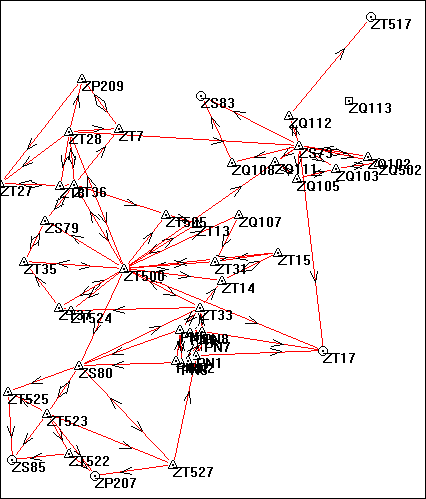
Fig. 4. Re-survey of Greater Lusaka control points
Part of the two students’ work was to design and establish a new network in a part of the Lusaka having relatively rapid development. Hence 8 new points where established in South of Chilenje South.
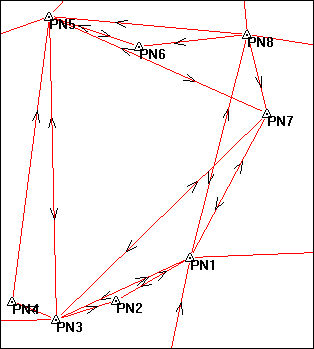
Fig. 5. New reference marks in Lusaka
This network was designed bearing in mind the use of the points in conventional methods. Hence intervisibility was considered.
3.0 The IGS station
The IGS
station ZAMB was processed in a regional network of 25 IGS stations which
includes a subset of eight IGS global stations: HRAO (South Africa), SUTH (South
Africa), CAS1 (Antarctica), ASC11 (Ascension Island), KERG (Kerguelen Islands),
MALI (Kenya), GOUG (Gough Island) and MAW1(Antarctica).
In
determining ZAMB's preliminary ITRF coordinates, sixteen ZAMB 24 hour rinex
files were processed in this regional network. Processing was done using the
GAMIT package. The primary solutions were performed with loose apriori
uncertainties to provide an unconstrained initial solution. The GAMIT solutions
files were further processed by the GLOBK Kalman filter. This additional stage
uses the estimates and associated covariance matrices for station coordinates,
orbital parameters, earth-rotation parameters, and source positions generated
from analyses of the primary
observations.
The a
priori well known positions of the eight IGS global sites were used to
constrain the reference frame by minimising the position deviations of these
stations. Only translation parameters
were estimated. Orientation of the reference frame was maintained through the
IGS orbit and IERS Earth
orientation
values. The preliminary results are encouraging and can be used as interim ITRF
coordinates. The ITRF values will improve as more data are collected. A
firmware upgrade to the SNR8000 GPS receiver (planned for July 2002) will also
improve data quality.
ITRF
2000 geocentric coordinates epoch (2002.44) for ZAMB:
X = 5415353.0847 (m)
± 71 mm
Y
= 2917209.7255 (m) ± 46 mm
Z
= -1685888.9341 (m) ± 18 mm
WGS84
coordinate values epoch (2002.44) for ZAMB:
Latitude =
15° 25' 31.94930" S
Longitude =
28 18' 39.63772" E
Height =
1324.909 m
Having the station coordinates so determined, we will then be able to connect all local networks to this station, bearing in mind ZAMB observation rates and other parameters. We now give an example of a recent GPS campaign undertaken in June 2002.
Fig. 6. Zambia Tertiary, ZT500 station at Mulungushi House, before installation IGS GPS antenna
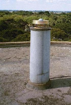
Fig7. ZAMB AshTech VZ –12 GPS antenna
3.1 GPS Campaign in Eastern Zambia
As a follow up to the previous works in 1999 and 2000, KTH together with UNZA resumed the GPS surveys, but this time to carry out the work in Chipata, Eastern Zambia. Three GPS receivers (Leica’s 299/233/333 series) were used. ZAMB was a considered part of the network. Computations of this network is in progress.
TT111, TT110 and TT113 are points lying on the peripheral of the town, monumented on the surrounding hills. Results of the earlier observations were preliminary. Thus the Chipata campaign was aimed at determining better coordinate solution for the three points. These points are deemed crucial as they will obviously help the ZSD regional office densify the town reference marks used for property surveys to mention just one.
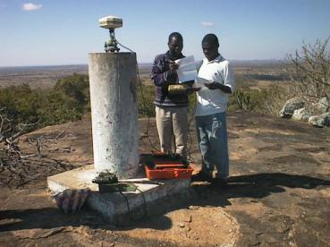
Fig. 9. GPS surveys in Eastern Zambia
4.0
Conclusion
The installation of the IGS station is certainly very welcome as it will be possible now to realize reliable networks. The transformation parameters will now be determined more accurately. The station will now enable us calculate the networks sighted above. Moreover, it will now be possible to carry out surveys with only one GPS receiver thereby making it possible for private surveyors and surveying companies to cut costs. This will also entail higher productivity and possibly a quicker land delivery. However, it is still not possible to acquire GPS receivers. Partnerships with potential users/providers of GNSS technologies will be the solution.
The following seem to be the immediate tasks to be undertaken following the installation of the station:
· Re-compute the geocentric geoid over Zambia and subsequently the local geoid
· Establishment of control points especially in rural areas
· Re-computation of the GPS networks
The above tasks will certainly call for funding and the partnerships earlier mentioned is the obvious way out.
5.0
References
2. Ansenjo E.; Nsombo P. ; Sjoberg L. E. and Stoimenov G. (2002). Sustainable Development in Zambia SAREC/SIDA KTH Report.